Tidal Gauge Information: Low Water Levels
In the hours before Hurricane Irma struck Florida, the water in some bays and inlets began to retreat. The phenomena were seen along the west coast of Florida, from Naples to Tampa, along with the Florida Panhandle and as far west as Mobile, AL.
The water had been dragged toward the hurricane due to strong offshore winds. Offshore winds are winds blowing from land to water. These winds persisted for hours before Irma’s landfall, causing many tidal gauges to report water levels below mean sea level (MSL). Mean sea level is a tidal datum, and the mean of hourly heights observed over the National Tidal Datum Epoch, a 19-year period from 1983-2001.
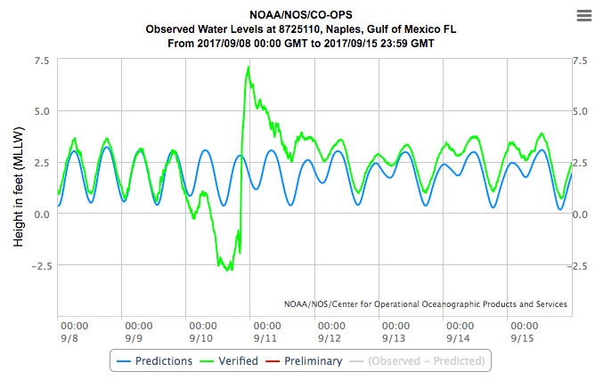
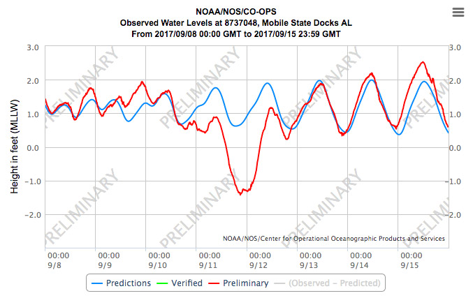
Gauges from the following stations recorded these preliminary and verified water levels from September 8-15, 2017.
Naples, FL

- Lowest Level: -2.808 ft. on September 10th at 11:06 AM; predicted level was 0.646 ft.
- Highest Level: 7.113 ft. on September 10th at 7:06 PM; predicted level was 1.882 ft.
Mobile Bay State Docks, AL

- Lowest Level: -1.427 ft. on September 11th at 3:54 PM; predicted level was 0.662 ft.
- Highest Level: 2.530 ft. on September 15th at 6:42 AM; predicted level was 1.934ft.