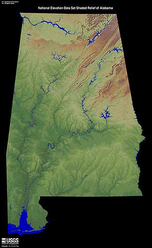
Geography
Many different geographic features determine the climate and weather events that are seen across Alabama. There are well defined physiographic divisions in Alabama. From north to south, they are the East Gulf Coastal Plain, Piedmont Ridge, Alabama Ridge and Valley, Cumberland Plateau, and the Highland Rim.
Alabama stretches from 30° 11' N to 35°
00' N (Latitude) and 84° 53' W to 88° 28'
W (Longitude), which makes the state roughly 190
miles wide and 330 miles long.
Only 3.2% of the area of the state is considered
water. The state’s coastline spans 53 miles along
the Gulf of Mexico. Some of the major lakes in the
state are the Walter F George Reservoir, Wheeler
Lake, Martin Lake and Guntersville Lake. Major
river systems include the Alabama, Black Warrior,
Chattahoochee, Tennessee and Tombigbee rivers.
Elevation Changes: Elevation changes across the
state range from sea level along the eastern Gulf
Coast Plain to the highest point at Mount Cheaha
(2,413 ft.) near Delta, AL in Clay County.
The prevailing westerly winds are found between
30˚N and 60˚N, and these prevailing winds help
steer large-scale weather systems and have a
significant impact on the weather and climate of
Alabama. Winds are primarily out of the southwest
during the summer and from the northwest during
the winter.
Source: Alabama Relief 1 | EROS