Hurricane Michael: Storm Surge
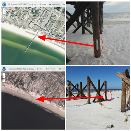
The United State Geological Survey (USGS) deployed more than 30 storm tide sensors across the Florida Gulf Coast, ahead of Hurricane Michael's landfall. The sensors measure water level data and barometric pressure at 30-second intervals and are a point of verification, in addition to looking for high water marks created by debris to help identify the height of flood waters or storm surge. Data based on the post-storm survey conducted by USGS, FEMA, and members of NOAA suggest that the storm surge reached a height of 15.55 ft. in Mexico Beach.
You can read more about the changes along the Florida coastline in this article published by the USGS.
NOAA created an interactive map of before and after images along Hurricane Michael’s path. Use the map to examine more of the damage caused by this historic storm.